Rangitata › Rangitata
Rangitata River at Klondyke
93.5m³/s
Sat, 17 Oct, 11:05 pm · 23 min ago
Good ClearingClearing: 2.8 d since the last peak, still 1.5× the 30-day median; glacial, milky in warm weather
Good for about 17 h more · drops below 85 m³/s around Sun 4:45 pm, from this recession
- 3 h change
- -0.46 m³/s
- Steady for
- 14 h
- 7-day peak
- 206Thu, 15 Oct, 5:15 am
- 30-day median
- 63.8
- 30-day range
- 39.3 – 206
- Mean annual flood
- 1,230 m³/s
- 1-in-10-year flood
- 2,150 m³/s
- Highest gauged
- 1,427 m³/s
- Water temperature
- 14.4 °C
- Stage
- 0.84 m
- Recession
- halves in 26 hfitted to this recession, toward 70.0
JBNZ: 85 m³/s at Klondyke plus the RDR take for SH1 to the intake; the gorge has been boated at 150; the upper thresholds are placeholders
Flow
m³/s · New Zealand timeDrag to zoom, double-click to reset. Download CSV
Water temperature
°C, last weekRecent rises
detected from hourly means| Peak | From | To | Rise | Settled |
|---|---|---|---|---|
| Thu, 15 Oct, 4:00 am | 70.0 | 204 | 2.9× | 42 h |
| Thu, 8 Oct, 9:00 am | 39.6 | 57.1 | 1.4× | 7 d |
JBNZ river guide
Rangitata River, sections that cite this gauge are markedSections
Rangitata RiverIncluding the Havelock and Clyde rivers. Deep Stream (Mesopotamia) and Deep Creek (Mt Potts) are non-boating areas.
Sea to SH1 Class 2
Boulders, braided · 18 km · 5.5 m/km
Launch Rangitata Huts, north side
SH1 to the intake Class 3
Boulders · 40 km · 3.9 m/km
85 cumecs at the Klondyke recorder plus the RDR abstraction (the RDR takes water between the gauge and this section). Rangitata now 93.5 m³/s, above the minimum.
Launch Below SH1 on the north side, at times
Intake to the gorge Class 4
Rapids, rocks · 6 km · 10 m/km
Has been boated at 150 cumecs. Rangitata now 93.5 m³/s.
Launch Launch ramp at the head of the gorge using the easement on the boundary of Stew Point and White Rock stations; permission from Stew Point, 03 696 3706. Beware of the silt and sinking sand.
Note the waterfall. Shut the gate. This is also the access used by Rangitata Rafts.
Gorge to Turnagain Point Class 1
Shingle, braided · 13 km · 1.4 m/km
Launch Ben McLeod Station, beside the road
Turnagain Point, also known as Red Rocks, is a red-coloured bluff on the true right where the Rangitata Gorge road comes closest to the river.
Turnagain Point to the Clyde Class 1
Shingle, braided · 25 km · 5.2 m/km
Clyde
Not usually boatable
Clyde to the Havelock, Forbes Junction Class 3 Closed 1 March to 31 July
Boulders, braided · 15 km · 12 m/km
From the Jet Boating New Zealand Canterbury river information sheet of July 2024, transcribed by hand on 17 October 2026. Uplifting is whether the 5-knot limit is lifted for the section. JBNZ can update the sheet at any time; flo checked it 4.9 h ago. Open the PDF.
Weather
at Rangitata · Open-Meteo10pm
Partly cloudy
6.1°
–
2 SE
1am
Fog
6.1°
–
3 W
4am
Fog
4.9°
–
3 W
7am
Fog
5.8°
–
5 W
10am
Fog
13.5°
–
1 SE
1pm
Clear
15.4°
–
9 SE
4pm
Clear
16.8°
–
10 E
7pm
Clear
15.0°
–
5 E
10pm
Clear
11.1°
–
6 W
1am
Clear
10.3°
–
11 W
4am
Fog
8.4°
–
16 NW
7am
Fog
7.3°
–
17 NW
Sat Partly cloudy 6.1°/ 5.7° dry
Sun Fog 16.8°/ 4.9° dry
Mon Fog 16.7°/ 7.3° dry
Tue Fog 17.8°/ 8.7° dry
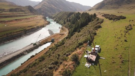
Rangitata River KlondykeOpen live cam ↗
Outdoor Access· 1.4 km from the Rangitata gauge · subscription